Geographical Information Systems
What WE Do
Taylor GeoServices (TGS) has effectively used GIS technology to aid in many investigations and
assist organizations in targeting grant applications.
A Geographic Information System (GIS) is a powerful tool that allows for the creation, storage, analysis, management, and presentation of data including maps, databases, and statistical analysis. GIS allows the user to incorporate many datasets into one database. This integration allows for easier holistic analysis of the data than traditional approaches.
Data that can be incorporated into a GIS includes points, lines, and polygons, as well as images (such as aerial photographs), and topography (such as Digital Elevation Models, LiDAR, and contour lines). The visual representation of such data can be a powerful tool in research, planning and marketing.
Examples of applications where GIS has been used include:
Site Location Maps
can be used to identify and display items of interest including topography, buildings, streams, boundaries, natural features, trails, and vegetation.
Land Use Planning
Geologic and Hydrogeologic Maps
Aerial Photography Analysis
includes the identification of vegetation, tree canopy, geologic, hydrogeologic, or geographical features of interest. Overlaying historical aerial photographs can also show changes in land use over time.
Case Studies.
Case studies
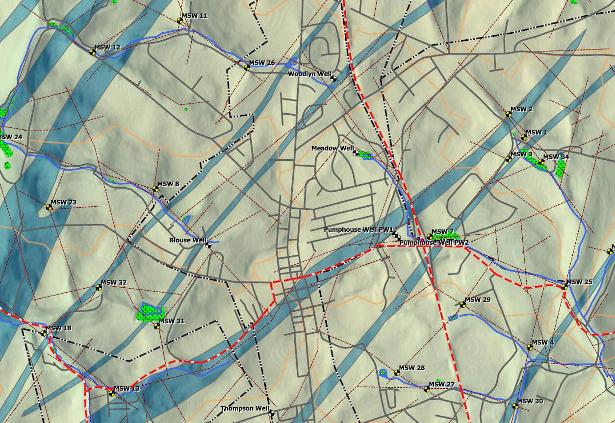
Shrewsbury Borough Municipal Water Supply
Shrewsbury, York County, Pennsylvania

Taylor GeoServices (TGS) staff has been providing technical geologic, hydrogeologic, compliance and operations support services to Shrewsbury Borough and have been responsible for developing all aspects of the geologic and hydrogeologic characterization work to the borough since 2010, including developing corresponding geologic and hydrogeologic maps.
The borough is in a drought sensitive headwaters aquifer system underlain by Precambrian/Cambrian schist bedrock of the Wissahickon Formation. TGS utilized GIS to model possible production well locations (in this case, production wells are defined as those that would produce 70 to 100 gallons per minute and have sufficient recharge area to sustain this withdrawal). In order to identify production wells, several factors were analyzed in GIS including fracture trace analysis, defining exclusion zones, and developing hydrogeologic criteria that would result in high yielding wells by evaluating topographic position, overburden thickness, and proximity to highly fractured zones and Triassic age metabasalt intrusion zones. The resulting map identified potential wells sites with characteristics that required further investigation for production well placement.
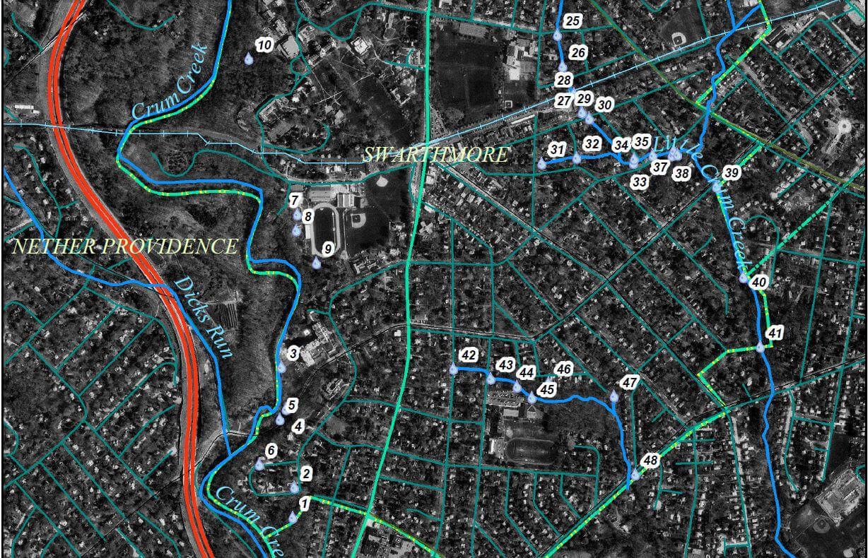
Swarthmore Borough
Swarthmore, Delaware County, Pennsylvania
Taylor GeoServices (TGS) staff has provided technical geologic, hydrogeologic, compliance and support services to Swarthmore Borough, including the development of several GIS maps for use in the borough. Maps and data collection are also used for grant applications and permit renewals.
One such investigation includes the identification, prioritization and presentation for field screening of stormwater outfalls in the borough.

Delaware County Soil Conservation District
Delaware County, Pennsylvania

Taylor GeoServices (TGS) staff provided the Delaware County Soil Conservation District with a GIS map project and corresponding database in an effort to help the Conservation District improve the mapping and data management of their stormwater outfall monitoring and minimum control measures. The project was developed using a GIS base map and database, which allows for better recording, display, and reporting of the stormwater outfall data required by the Pennsylvania Department of Environmental Protection.
Benefits of this map project include the potential for future expansion of the database and map display. Additional information can easily be entered into the corresponding database and then displayed on the maps. Other map layers (such as aerial photography, parcel data, streams, etc.) can also be easily added to the project.
Chester-Ridley-Crum (CRC) Watersheds Association
Delaware County, Pennsylvania
Taylor GeoServices (TGS) staff provided the CRC Watersheds Association with a GIS map that identified property owners adjacent to the stream. In conjunction with data collected by the CRC Watersheds Association about stream conditions, TGS was able to develop a map with conditions contributing to the degradation of the stream habitat, corresponding property owners, and actions the property owners could take to improve the stream habitat quality along their property.

Location
Longitude: 75° 24.23'W
Elevation: 380+/- feet msl
